Bartram Trail – Warwoman Dell to Rabun Bald
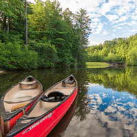
Bartram Trail – Warwoman Dell to Chattooga River Lenght: 18.8 miles Estimated Time: 8-10 Hours (287 reviews) Type: Point-to-point trail Difficulty: Hard Elevation: 640 ft elevation gain total Hours: None Given Emergency Contact: (706) 754-6221 Address: None Given GPS Coordinates: 34.8765° N, 83.7234° W Allowed Activates Hiking Trail Running Nature Photography Birdwatching Dog Walking (on leash) Backpacking Camping (dispersed) River Access Fishing Amenities & Logistics PARKING Free parking at Warwoman Dell Recreation Area Additional parking along Warwoman Road Russell Bridge parking area (southern terminus) Sandy Ford Road access (high-clearance vehicle recommended) RESTROOMS & FACILITIES Restrooms temporarily unavailable at Warwoman Dell (check status) No facilities along remote trail sections Water sources require purification Carry all needed supplies KID FRIENDLY Not suitable for young children due to length and remoteness Warwoman Dell area excellent for families with short trails River access may appeal to older children Educational opportunities about Native American history PICNIC AREAS Two picnic shelters at Warwoman Dell Scattered picnic tables along recreation area No facilities along wilderness trail sections Primitive camping opportunities FEES No entrance fees Free parking at all access points Trail Overview Following William Bartram’s historic 1775 route, this challenging section travels from the recreation area at Warwoman Dell to the pristine waters of the Wild and Scenic Chattooga River. The trail offers a true wilderness experience through some of Georgia’s most remote and biodiverse forest lands. Departing Warwoman Dell’s lush valley, the trail climbs over Rainy Mountain (2,560 feet) before following pleasant ridgeline walking on old forest roads. The terrain alternates between moderate climbs and gentle descents, offering excellent opportunities to observe the region’s exceptional botanical diversity. The route passes through various forest ecosystems, from dense hardwood coves to drier ridge-top environments. Wildlife sightings are common, including deer, wild turkey, and various bird species. The trail’s remote character means extended periods without encountering other hikers. After crossing several mountain knobs and ridges, the trail descends to join the Chattooga River Trail at historic Sandy Ford. This ancient river crossing served Cherokee natives, early settlers, and traders for centuries. Archaeological evidence includes dugout canoes dating back over 200 years. Key Highlights: Wild and Scenic Chattooga River access Rainy Mountain crossing Historic Sandy Ford Diverse forest ecosystems Wildlife viewing opportunities Pristine wilderness experience Gear Up for Your Next Adventure Every trail has its challenges. Make sure you’re prepared with gear that goes the distance. Shop Now Activity-Specific Information For Hikers: Long wilderness section requires self-sufficiency. Multiple stream crossings and elevation changes. Allow full day or plan overnight camping. For Backpackers: Dispersed camping available throughout. River access provides excellent camping opportunities. Water purification essential for stream sources. For Photographers: Chattooga River access offers dramatic water photography. Forest diversity provides varied shooting opportunities. Historic Sandy Ford has cultural significance. For Anglers: Chattooga River renowned for trout fishing. Native brook trout and stocked rainbows. Georgia fishing license required. Water Access Information River Conditions Chattooga Wild and Scenic River Sandy Ford historic crossing Multiple tributary streams Warwoman Creek access WATER SAFETY River currents can be deceptively strong Water levels change rapidly with weather Cold water temperatures year-round Wear appropriate footwear for crossings RECREATION NOTES Part of National Wild and Scenic River System Exceptional water quality Diverse aquatic ecosystems Leave No Trace principles essential Safety & Preparation Conditions: Trail generally in good condition with yellow blazing. River access requires careful navigation. Some overgrown sections in summer. Recommended Gear: Sturdy hiking boots, insect repellent, water purification, camera, rain gear, river shoes for crossings. What to Bring: 3+ liters of water plus purification Full day’s food supply First aid kit Navigation tools Insect protection River crossing footwear Hazards/Warnings: Multiple creek crossings Potential tick exposure River currents can be strong Remote wilderness sections Weather changes affect river levels Weather Considerations: Summer brings heavy vegetation and significant insect activity. Spring offers best water flow but challenging crossings. River levels rise quickly after rain.
Bartram Trail – Rabun Bald to Warwoman Dell
Bartram Trail – Rabun Bald to Warwoman Dell Lenght: 13.5 miles Estimated Time: 6-8 Hours (412 reviews) Type: Point-to-point trail Difficulty: Hard Elevation: 2,176 ft elevation loss Hours: Dawn to dusk, year-round Emergency Contact: (706) 754-6221 Address: None Given GPS Coordinates: 34.9234° N, 83.6543° W Allowed Activates Hiking Trail Running Photography Birdwatching Dog Walking (on leash) Backpacking Camping (multiple sites) Waterfall Amenities & Logistics PARKING Free parking at Rabun Bald (via Beegum Gap) Free parking at Warwoman Dell Recreation Area Two parking areas at Warwoman Dell (upper and lower) RESTROOMS & FACILITIES No restrooms at Rabun Bald trailhead Restrooms temporarily unavailable at Warwoman Dell (check current status) Water fountain located halfway through Warwoman Dell area Picnic pavilions and shelters at Warwoman Dell KID FRIENDLY Long distance challenging for most children Warwoman Dell area very family-friendly with easy trails Multiple waterfalls appeal to kids Educational CCC history and interpretive signs Short nature trail options for families PICNIC AREAS Two CCC-built picnic shelters at Warwoman Dell Multiple picnic tables throughout recreation area Large pavilion with tables, fireplace, and grills Small covered picnic area with stone fireplace FEES No entrance fees Free parking at all locations Trail Overview Descending from Georgia’s second-highest peak, this spectacular section of the Bartram Trail winds southwest for thirteen miles through some of the state’s most diverse and beautiful terrain. The route offers an incredible combination of mountain vistas, cascading waterfalls, and rich historical significance. Beginning at Rabun Bald’s 4,696-foot summit, the trail descends steadily through changing forest ecosystems. The first miles pass through the mountain’s distinctive heath zone before entering dense hardwood forests filled with rhododendron and mountain laurel. The moderate descent offers excellent recovery after the summit climb. The trail reaches Courthouse Gap at just over 10 miles, passing an intersection with the green-blazed Pinnacle Knob Trail. The side trip to Pinnacle Knob (less than two miles round-trip) offers outstanding 180-degree views and is highly recommended for hikers with extra energy. The final miles leading to Warwoman Dell showcase the trail’s most impressive water features. The route passes through Martin Creek’s slot canyon and spectacular double-tiered waterfall before reaching the historic Becky Branch Falls just minutes from the road crossing. Key Highlights: Becky Branch Falls Martin Creek Falls (double-tiered) Pinnacle Knob side trail Multiple backcountry campsites Warwoman Dell Recreation Area Historic significance Gear Up for Your Next Adventure Every trail has its challenges. Make sure you’re prepared with gear that goes the distance. Shop Now Activity-Specific Information For Hikers: Long descent requires good knee conditioning. Multiple water features provide photo opportunities and rest stops. Allow full day for completion. For Backpackers: Excellent campsites throughout, many near water sources. Martin Creek Falls camping particularly scenic. Multiple resupply options at Warwoman Dell. For Photographers: Martin Creek Falls offers double-tiered cascades. Becky Branch Falls easily accessible. Golden hour lighting in hardwood forest exceptional. For Nature Enthusiasts: Exceptional biodiversity along elevation gradient. Spring wildflowers outstanding. Stream ecosystems support diverse wildlife. Safety & Preparation Current Conditions: Excellent trail conditions with clear yellow blazing. Multiple water features and camping opportunities. Some technical sections require careful attention. Recommended Gear: Hiking boots, ample water capacity, camera, trekking poles for steep sections, layers for elevation changes. What to Bring: 3+ liters of water per person Trail snacks and lunch First aid kit Navigation tools Camera for waterfalls Insect repellent Hazards/Warnings: Long sustained descents stress knees Multiple stream crossings Slippery rocks near waterfalls Potential for afternoon thunderstorms Technical rocky sections Weather Considerations: Trail descent means warming temperatures throughout hike. Stream crossings can be challenging during high water. Summer brings heavy vegetation and insect activity.